King of Prussia in the year 1772)  Copper etching by Homann 1775. This map published by P. Santini in Venice, 1776. RARE!  The parts colored are those ceeded by Poland. In the lower left is the Wart Canisco and Pobiancea River and the town of Birnbaum. In the lower center is Wielowice and Labiszin. The map extends as far east as Rossel, Plenow and Rabawen.
Maps, Poland, West Prussia, rare!, Wart Canisco, Pobiancea River, Birnbaum, Rossel, Plenow, Rabawen, Homann
King of Prussia in the year 1772)  Copper etching by Homann 1775. This map published by P. Santini in Venice, 1776. RARE!  The parts colored are those ceeded by Poland. In the lower left is the Wart Canisco and Pobiancea River and the town of Birnbaum. In the lower center is Wielowice and Labiszin. The map extends as far east as Rossel, Plenow and Rabawen.

Maps, Poland, West Prussia, rare!, Wart Canisco, Pobiancea River, Birnbaum, Rossel, Plenow, Rabawen, Homann

Regular price $740.00 $0.00
Shipping and Taxes calculated at checkout.

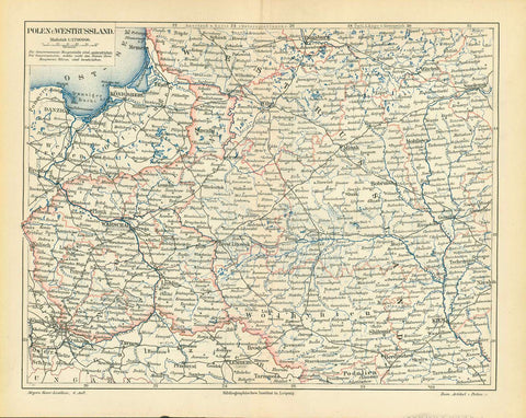
"Carte de la Prusse Occidentale ou sont tracees les provinces cedees par la Pologne au Roi de Prusse" (Map of West Prussia showing the provinces which Poland had to cede to the King of Prussia in the year 1772)

Copper etching by Homann 1775. This map published by P. Santini in Venice, 1776. RARE!

The parts colored are those ceeded by Poland. In the lower left is the Wart Canisco and Pobiancea River and the town of Birnbaum. In the lower center is Wielowice and Labiszin. The map extends as far east as Rossel, Plenow and Rabawen.

Original antique print 

Clean. Light browning on vertical centerfold. Very good condition.

44.7 x 64.5 cm (17.6 x 25.4")  interior design, wall decoration, ideas, idea, gift ideas, present, vintage, charming, special, decoration, home interior, living room design 


Share this Product


More from this collection