Gift ideas for people that "have everything". One of the best and easiest ways to find a print or topic is to use the "Search" function in the upper right hand corner. Important news for our US customers: ALL PRINTS ON OUR WEBSITE ARE OVER 100 YEARS OLD. THEY ARE CUSTOMS-FREE FOR IMPORT INTO THE USA.
Gift ideas for people that "have everything". One of the best and easiest ways to find a print or topic is to use the "Search" function in the upper right hand corner. Important news for our US customers: ALL PRINTS ON OUR WEBSITE ARE OVER 100 YEARS OLD. THEY ARE CUSTOMS-FREE FOR IMPORT INTO THE USA.
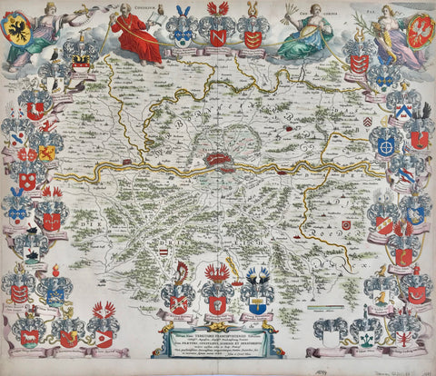
"Tabula Delphinatus Vulgo le Gouvernment General Du Dauphine"
Copper engraving map by Johann Baptist Homann. Original hand coloring. Published ca 1720.
Very detailed map of the Freanch Alps. In the upper left is Lyon. On the left is the Rhone River. At the top center of the map is Annecy. In the lower right is Turin, Saluzzo and Mondovi. Below th e allegorical cartouche is a fighting scene at the foot of the mountains.
Original antique print
A few signs of age and use. Hardly visible repair on lower centerfold. Some light spotting in the margins.
48 x 57 cm ( 18.8 x 22.4 ")
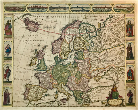
For further maps of France and Italy go to our main website: