Gift ideas for people that "have everything". One of the best and easiest ways to find a print or topic is to use the "Search" function in the upper right hand corner. Important news for our US customers: ALL PRINTS ON OUR WEBSITE ARE OVER 100 YEARS OLD. THEY ARE CUSTOMS-FREE FOR IMPORT INTO THE USA.
Cart 0
Hand-colored copper etching by Bouclet. Published on behalf of the French Ministry of the Marine. Paris, 1793  Map reaches from Cabo Prieto in the east to Cabo Ortegal, the northernmost landmark of Spain. There are 7 coastal elevation profiles shown.

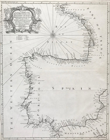
Maps, Spain, coastal map, elevation profiles, Cabo Prieto, Cabo Ortegal, Bouclet

Regular price $1,500.00 $0.00
Shipping and Taxes calculated at checkout.

"Cotes d'Espagne Asturies et Partie de Galicie d'après les Plans levées en 1788 par Don Vicente Tofino Officier de la Marine d'Espagne publie par Ordre du Ministre de la marine pour le Service des Vaisseaux de la Republique Francaise au Depot des Cartes, Plans et Journaux de la Marine 1793"

Hand-colored copper etching by Bouclet. Published on behalf of the French Ministry of the Marine. Paris, 1793

Map reaches from Cabo Prieto in the east to Cabo Ortegal, the northernmost landmark of Spain. There are 7 coastal elevation profiles shown.

Map has several vertical creases near centerfold and on right side. There are traces of age and use in margins. Lower right margin has black ink hand writing. Small piece of right margin has been added. Some fraying on margin edges.

57 x 86,3 cm (ca. 22.4 x 34")


Share this Product


More from this collection