Gift ideas for people that "have everything". One of the best and easiest ways to find a print or topic is to use the "Search" function in the upper right hand corner. Important news for our US customers: ALL PRINTS ON OUR WEBSITE ARE OVER 100 YEARS OLD. THEY ARE CUSTOMS-FREE FOR IMPORT INTO THE USA.
Cart 0
"Landtcarte Uon dem Daenischen Walde". Copper etching by Mejer-Husum, 1652. Modern hand coloring.  For a 30% discount enter MAPS30 at chekout   At the top of the map is the Ecklnforder Bay and in the lower right is the Kieler Bay and at the bottom Kiel. A very detailed map of the area.  Original antique map!

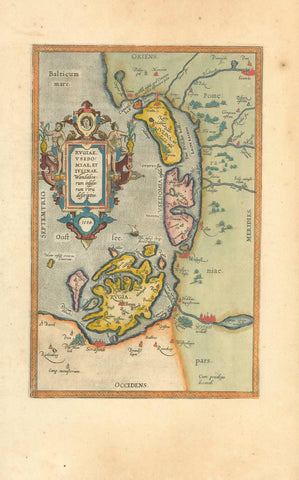
Maps, Germany, Schleswig Holstein, Kiel, Eckinforder Bay, Mejer-Husum

Regular price $240.00 $0.00
Shipping and Taxes calculated at checkout.

"Landtcarte Uon dem Daenischen Walde". Copper etching by Mejer-Husum, 1652. Modern hand coloring.

For a 30% discount enter MAPS30 at chekout 

At the top of the map is the Ecklnforder Bay and in the lower right is the Kieler Bay and at the bottom Kiel. A very detailed map of the area.

Original antique map!

All margins have been widened. Repaired tear in lower right area of map. Map image is very clean. General condition is otherwise Good.

24 x 30.2 cm (9.4 x 11.8")


Share this Product


More from this collection