Maps, Europe, Population
"Karte der Bevoelkerungs Dichtigkeit von Europa"
Xylograph published ca 1875. Attached to the map is a separate page with very detailed statistics on both sides of the page. The population for each country and it regions is given.
Original antique print
For a 30% discount enter MAPS30 at chekout
Map image: 10 x 15.5 cm (3.x 6.1")
Keywords:
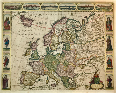
Scandinavia (Iceland, Norway, Sweden, Finland, and Denmark); the British Isles (the United Kingdom and Ireland); Western Europe (France, Belgium, the Netherlands, Luxembourg, and Monaco); Southern Europe (Portugal, Spain, Andorra, Italy, Malta, San Marino, and Vatican City); Central Europe (Germany, Switzerland, Liechtenstein, Austria, Poland, the Czech Republic, Slovakia, and Hungary); South Eastern Europe (Slovenia, Croatia, Bosnia and Herzegovina, Serbia, Montenegro, Albania, Macedonia, Romania, Bulgaria, Greece, and the European part of Turkey); and Eastern Europe (Estonia, Latvia, Lithuania, Belarus, Ukraine, Moldova, the European portion of Russia, and by convention the Transcaucasian countries of Georgia, Armenia, and Azerbaijan), population density, Human densities, per square kilometer or square mile
interior design, wall decoration, ideas, idea, gift ideas, present, vintage, charming, special, decoration, home interior, living room design