Maps, Europe, Germany, Spain, France, Italy, North Africa, Inhabitants, Chatlain
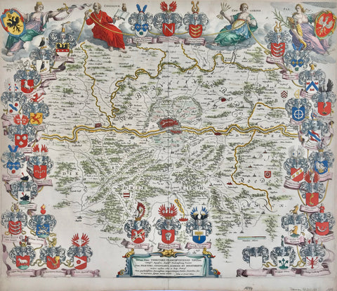
"Carte De La Germanie Et Les Diferents Etats Ou Ses Peuples Ont Porte Leurs Conquestes"
For a 30% discount enter MAPS30 at chekout
Copper engraving map by Henri Abraham Chatlain (1684-1743), published1720.
Hand colored.
Published in "Atlas Historique, Ou Nouvelle Introduction A l'Histoire, à la Chronologie & à la Géographie Ancienne & Moderne: Représentée dans de Nouvelles Cartes, Où l'on remarque l'établissement des Etats & empires du Monde, leur durée, leur chûte, & leurs differens Gouvernemens"
This map is a treasure for historians of the ancient kingdoms of Europe.
In the lower left are tables with the names of the earliest peoples in Europe and their rulers. Direct on the left side of the map are the names of rulers from Castille, Leon, Aquitaine, Italia, etc. On the right side of the map are the names of the early rulers of France including North Africa. On the lower right are tables of villages and States on the map with the keys to finding the places on the map. The vertical centerfold of this map has been flattened. Light parallel folds near centerfold.
Original antique print
The margins have some wrinkles. Repaired tear on lower margin edge.
Natural age toning. Normal signs of age and use.
Map image with surrounding text: 34 x 45 cm (13.3 x 17.7")
Page size: 43 x 51 cm (16.9 x 20 ")