Maps, China, Korea, Japan, Bleau
Regular price
$2,115.00
Shipping and Taxes calculated at checkout.
|
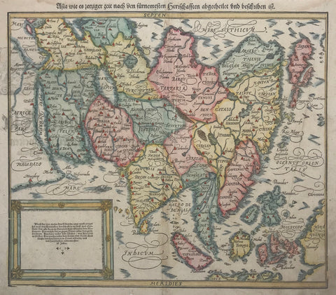
"Imperii Sinarum Nova Descriptio"
This attractive map of China includes Korea as a peninsula, Japan and Formosa. It was originally made by Joan Blaeu after Martino Martini.Martini was a Jesuit missionary who made the first atlas of China in 1654. This map was first published by Blaeu.
Some of the plates of the Blaeu atlas were acquired by Covens (1697-1774 ) and Mortier ( 1722-1794 ). This map is from the Covens and Mortier edition which is rarer than the Blaeu edition. This map in original hand coloring was published ca 1695.
One of the interesting features of the map is the Great Wall of China at the top of the map. The cartouche shows Chinese with various native fruits and flowers.
This is a special map for collectors of Chinese and Asian maps and is historically interesting for historians of Asia.
Our maps are well packed and sent registered air mail and insured.
I am a member of the International League of Antiquarian Booksellers.
|