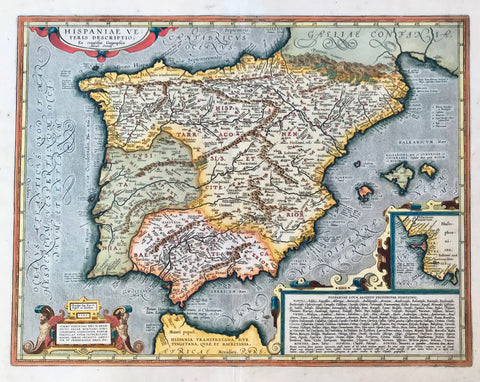
Maps, Spain, España, Iberian Peninsula, Balearic Islands, Waldseemueller, Ptolemy
Regular price
$2,400.00
Shipping and Taxes calculated at checkout.
"No Title" . Woodcut from "Claudii Ptolemaie Alexandrini... Geographiae", by Martin Waldseemüller-Laurent Fries. Published in Strasbourg, 1525. (After editions of 1513 and 1522 by Waldseemüller).
This very attractive Potolemic map shows the Iberian penninsula with the Balearic Islands. On the sides are narrow borders showing degrees of latitude, that are not drawn on map. At the bottom is an Italian distance legend. Verso: Text in Latin.
Original antique print
Map has a wider margin than shown and has light toning. There is a small repair in lower margin along centerfold. Small tears in margins and margin corners have been repaired. Overall condition is Very Good for its age.
29 x 42 cm ( 11.8 x 16.5 ")