"Patavini Territorii Corographia, Iac. Castaldo Auct."  Hand-colored copper etching by Giacomo Gastaldi (ca. 1500-ca. 1568) Original antique print   Published in "Theatrum Orbis Terrarum", the first world atlas ever printed. By Abraham Ortelius (1527-1598). Antwerp, 1573 (second edition)  West- oriented map of the Province of Padua in Italy. reaching from Vicenza to Venice and the Adriatic Coast between the rivers Zero (fiume Zero) and Adige (Etsch), or if you will between the Island of Mazzorbo and Choggia

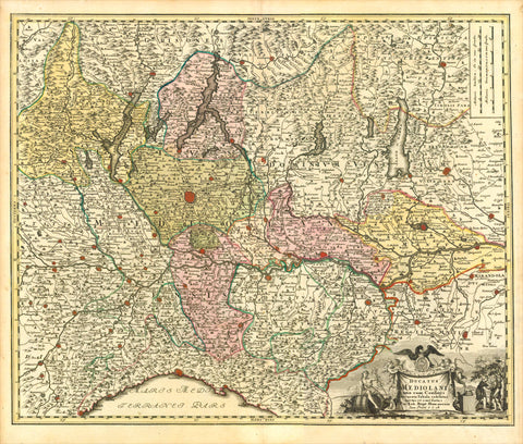
Maps, Italy, Padua, Vicenza, Venice, Adriatic Coast, Zero, Adige, Mazzorbo, Choggia

Regular price $360.00 $0.00
Shipping and Taxes calculated at checkout.

"Patavini Territorii Corographia, Iac. Castaldo Auct."

Hand-colored copper etching by Giacomo Gastaldi (ca. 1500-ca. 1568) Original antique print 

Published in "Theatrum Orbis Terrarum", the first world atlas ever printed. By Abraham Ortelius (1527-1598). Antwerp, 1573 (second edition)

West- oriented map of the Province of Padua in Italy. reaching from Vicenza to Venice and the Adriatic Coast between the rivers Zero (fiume Zero) and Adige (Etsch), or if you will between the Island of Mazzorbo and Choggia. Right through the center of map we see the Brenta river, along which wealthy Venetians built their Palladio villas. On the map also the town of Este, origin of one of the oldest and most noble families in Italy and in Europe.

Original antique print 

Laid down on China paper to prevent existing tears in upper margin from extending further into map. Margins a bit soiled. Reverse side has explanatory text print in Latin.

31,4 x 22,3 cm (ca. 12.4 x 8.8")


Share this Product


More from this collection