"Westphaliae Tabula tertia"  Deutschland, Westfalen  Original antique print    Hand-colored copper etching  Published in the pocket atlas  Publisher Janssonius based on Mercator  Amsterdam, 1648  On the reverse side is text in Latin about Westfalia.  The geographical area between the rivers Rhine, Main and Ruhr

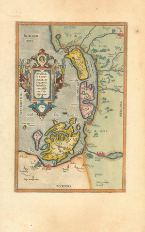
Maps, Germany, Westphaliae, Janssonius, Mercator

Regular price $170.00 $0.00
Shipping and Taxes calculated at checkout.

"Westphaliae Tabula tertia"

Deutschland, Westfalen

Original antique print  

Hand-colored copper etching

Published in the pocket atlas

Publisher Janssonius based on Mercator

Amsterdam, 1648

On the reverse side is text in Latin about Westfalia.

The geographical area between the rivers Rhine, Main and Ruhr

Original antique print 

Very good condition. Reverse side has explanatory text print

13,7 19,7 cm (ca. 5.4 x 7.8") 

interior design, wall decoration, ideas, idea, gift ideas, present, vintage, charming, special, decoration, home interior, living room design 


Share this Product


More from this collection