Maps, Europe, Jan Hillier
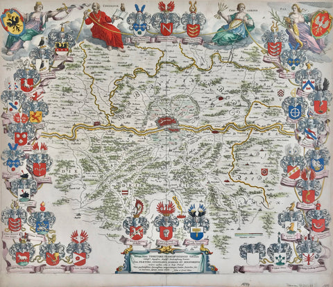
"L'Europe divisee dans ses Principaux Etats Subdivises en leurs Principales Provincese"
Hand-colored copper etching by J(an) L'(H)hillier and finished by Guillaume Danet
Dated: Paris, 1750
Decorative map of Europe. Shows the "0 Meridian" fixed under the rule of Louis XIII
in the year 1634 (Later- 1884 - changed to the Greenwich Meridian). Map has a bordure consisting of 110 coats of arms of cities, provinces, states. A winged "Europe" is ruling over the continent, blowing a trumpet with one hand, the other hand resting on the royal insignia of France. She is sitting on clouds over a baroque title cartouche, a female figure with a cornucopia and an armed soldier.
A large map reaching in the east well across the Volga river in Russia, showing the west coast of the Caspian Sea and Bagdad in the lower right corner. The bordure of so many coats of arms is holding this decorative map together.
There are only minor traces of age and use, such as expertly repaired small tears in margins. The map had been folded several times horizontally and vertically, because it was obviously published for an octavo size book or kept folded by a former owner. The creases are well smoothed out, so that, on the front side of the map, they do not matter.
In general this rare map is in a much better than good condition.
48,9 x 70,3 cm (ca. 19.3 x 27.7")