This absolutely rare and very attractive bird's eye view of Rome shows the location of the reconstructed antique buildings, sites etc of antique Rome within and beyond the walls. But it includes for example St. Peter on Mons Vaticanus. This is the first state of this map. Christoph Weigel used it as model for his similar map, which he published in his Atlas Scholasticus in Nuremberg, 1720

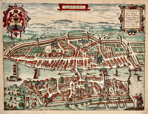
Maps, City Views, Italy, Rome, Samuel Faber

Regular price $540.00 $0.00
Shipping and Taxes calculated at checkout.

"Effigies Ant (quae) Romae Ex Vestigiis Aedificior Ruin Testimonio Vet. Autorum Fide Numis. Monumentis Aeneis Plumb. Sax. Figulinisq. Collecta Atque In Hanc Tabellam Redacta Atque De Scripta A. P. Ligorio Rom. Per XIIII Regiones Inquas Urbem Divisit Imp. Caesar Augustus"

Type of print: Copper etching

Color: Very attractive hand coloring

Author: Samuel Faber (1657-1716)

Published in: Atlas Scholastichodoeporicus oder immer stärcker anwachsender Schul- und Reisen-Atlas

Published: Nuremberg, 1716

Original antique print 

This absolutely rare and very attractive bird's eye view of Rome shows the location of the reconstructed antique buildings, sites etc of antique Rome within and beyond the walls. But it includes for example St. Peter on Mons Vaticanus. This is the first state of this map. Christoph Weigel used it as model for his similar map, which he published in his Atlas Scholasticus in Nuremberg, 1720

Condition: Excellent. Wide margins. Two vertical folds to fit book size.

30 x 43 cm (ca. 11.8 x 16.9") 

interior design, wall decoration, ideas, idea, gift ideas, present, vintage, charming, special, decoration, home interior, living room design


Share this Product


More from this collection